Best Matterport Pro3 Alternatives for Real Estate 3D Tours
The best Matterport Pro3 alternative depends on what you need to replace: the capture hardware, the spatial data, or only the immersive tour your client sees.
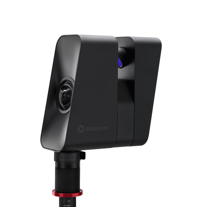
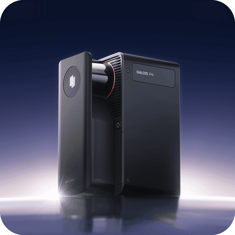
Same spaces.
Different economics.
The short answer
There is no single drop-in replacement.
For true spatial capture, start with Realsee P4 or M2, iGUIDE PLANIX R1, and Giraffe360 PRO. P4 is the premium LiDAR challenger; M2 lowers the entry price; iGUIDE changes the economics around measured floor plans; Giraffe360 turns the camera into a managed media service.
If the job is only an attractive listing walkthrough, use a 360 camera and tour platform. It can replace the deliverable without pretending to replace Pro3’s spatial-data capability.
The decision that changes the shortlist
Equivalent hardware vs alternative workflow
True spatial systems
These devices capture depth or geometry as well as imagery. They belong in a hardware-level comparison with Pro3.
- Realsee P4 and M2
- iGUIDE PLANIX R1
- Giraffe360 PRO
- Matterport Pro2: structured light, not LiDAR
Lower-cost tour workflows
These cameras capture panoramas that software links into a tour. They can replace the marketing experience, not the measured spatial model.
- Ricoh THETA X / Z1
- Insta360 X5
- Kuula, CloudPano, 3DVista or Panoee
- Separate floor-plan service when needed
A cheaper camera may replace the Pro3 for the marketing deliverable without replacing its spatial-data capabilities.
30-second shortlist
Quick picks by buying logic
Closest premium LiDAR challenger
Realsee Galois P4
Long range, very high-resolution imagery and broad spatial outputs—but a higher purchase price than Pro3.
See the evidence ↓Best lower-cost LiDAR entry
Realsee Galois M2
A materially lower camera price when 25 m range and Realsee’s credit model fit the work.
See the evidence ↓Best floor-plan-first business model
iGUIDE PLANIX R1
A lightweight capture system with no required subscription and per-project processing.
See the evidence ↓Best managed media workflow
Giraffe360 PRO
One capture feeds photos, plans, tours and video; price transparency is the tradeoff.
See the evidence ↓Best if LiDAR is unnecessary
360 camera + tour platform
The lowest-commitment path when the deliverable is an immersive marketing tour, not spatial data.
See the evidence ↓At a glance
Matterport camera alternatives compared
On mobile, swipe horizontally. Vendor specifications are labeled as claims where independent validation was not available.| Device / workflow | Capture technology | Range / accuracy | Capture | Upfront | Ongoing model | Best fit |
|---|---|---|---|---|---|---|
| Matterport Pro3Benchmark | 904 nm LiDAR + panoramic imaging LiDAR: Yes | 0.5–100 m (100 m tied to E57 workflow) ±20 mm at 10 m | Under 20 seconds per sweep Indoor and outdoor; IP43 | $3,995 camera; $4,495 Performance Kit | Professional plan or higher required; Active Spaces plus paid deliverables/add-ons | Teams that need an established spatial ecosystem, fast indoor/outdoor capture and broad client recognition. |
| Realsee Galois P4True spatial system | 905 nm LiDAR + 4/3-inch imaging system LiDAR: Yes | 0.1–100 m Under ±10 mm from 0.1–15 m (vendor claim) | About 16 seconds per scan point; 8 min / 100 m² claim Indoor and outdoor | $7,499 Standard; $7,999 Premium with 300 credits | Credit-based hosting and paid outputs; one credit activates one tour for 30 days | Premium residential, commercial and spatial-capture teams that value high-resolution imagery, long range and dense point-cloud output. |
| Realsee Galois M2True spatial system | 940 nm LiDAR + 4/3-inch imaging system LiDAR: Yes | 0.2–25 m ±20 mm at 10 m | About 15 min / 100 m² claim Indoor and outdoor; shorter range than P4 | $2,999 Standard; $3,799 Premium with 300 credits | Same Realsee credit model for hosting and paid outputs | Residential photographers and smaller commercial teams that want LiDAR-backed Realsee tours without paying for P4 range and imaging. |
| iGUIDE PLANIX R1True spatial system | Time-of-flight LiDAR + Ricoh THETA X LiDAR: Yes | Up to 40 m Typically ±10 mm camera-to-wall; floor-plan accuracy claim within 0.5% | HDR scan from about 8 seconds; 2,500 ft² in under 15 min claim Best documented for property interiors; confirm exterior workflow for the job | $2,599 in the US store | No required subscription; per-project processing starts at $7.99 for iGUIDE Instant | Real estate photographers who sell measured floor plans and want per-project economics instead of active-space hosting. |
| Giraffe360 PROTrue spatial system | LiDAR-assisted capture + panoramic imaging LiDAR: Yes | Could not verify for the current PRO model Could not verify a current public specification | About 30 seconds per capture claim Property capture workflow; confirm environmental limits with sales | Camera supplied through the service model; contact sales | Subscription / service bundle; current public price not listed | High-volume teams that want one capture to feed photos, floor plans, virtual tours, video and property pages. |
| 360 camera + tour platformAlternative workflow | Panoramic imaging; software linking/reconstruction LiDAR: No (camera-only workflow) | Not a depth-sensing range specification Not a measured spatial-capture replacement | Fast single-position panoramas; total time depends on coverage and platform Camera-dependent; usually suitable for ordinary listing capture | About $600–$1,000 for current Ricoh options, plus tripod/accessories | Choose a tour platform; hosting may be free, subscription-based or per tour | Agents and photographers whose client primarily needs an attractive walkthrough, MLS link and embed—not measured spatial data. |
What ownership actually means
Hardware → capture → processing → deliverables
Hardware
Camera, tripod, batteries and a compatible phone or tablet.
Capture
Depth sweeps or panoramas, alignment and on-site quality control.
Processing
Vendor cloud, service bureau or desktop authoring turns captures into a project.
Delivery
Tours, plans, photos, exports and hosting are what the client actually receives.
The cheapest camera can become expensive if every project needs paid processing. The most expensive camera can make sense if its premium deliverables are sold repeatedly. Compare the system, not the box.
System-by-system
What each option is actually optimized for
Matterport Pro3
Teams that need an established spatial ecosystem, fast indoor/outdoor capture and broad client recognition.
How the workflow feels
Scan in the Matterport app, allow automatic alignment, upload to the cloud, then order or export the deliverables your plan supports. It is the reference workflow because capture, processing, hosting and delivery live inside one mature system.
What the client can receive
- Interactive 3D tour and dollhouse
- Measurements and schematic floor plans
- MatterPak, E57, BIM and CAD-related add-ons
- Photos, video assets, branded and unbranded sharing
- Website embed and analytics
Limits that change the decision
- No Free or Starter plan compatibility for Pro3 uploads
- Professional cloud plan is part of ownership
- Technical exports and floor plans can add cost
- The ecosystem is convenient, but increases switching friction
Pro3 earns its premium when range, outdoor scanning, speed and spatial deliverables are billable. For a small residential listing that only needs an attractive walkthrough, it can be more system than the client uses.
Pricing note: Public US camera prices verified. Exact Professional subscription cost can vary by Active Spaces and billing term; confirm in Matterport’s live plan selector.
Realsee Galois P4
Premium residential, commercial and spatial-capture teams that value high-resolution imagery, long range and dense point-cloud output.
How the workflow feels
Capture from the built-in touchscreen with blind capture or co-capture options, upload later, edit in Realsee’s platform and spend credits to keep projects active or generate selected outputs.
What the client can receive
- 24K interactive 3D tour and spatial model
- Instant and manually drawn floor-plan options
- E57 / PLY point cloud and RAW export add-ons
- 3D model, snapshots and space video
- Website embed and public sharing
Limits that change the decision
- Highest upfront camera price in this shortlist
- Credits introduce project-month hosting math
- Several production outputs require extra credits
- A newer ecosystem means buyers should trial their real delivery workflow
P4 is not the budget alternative. It is the image-quality and long-range alternative—most compelling when a premium visual result and spatial exports both have value.
Pricing note: Premium kit includes 300 credits. Realsee currently sells credit packs; effective per-credit cost falls with larger packs.
Realsee Galois M2
Residential photographers and smaller commercial teams that want LiDAR-backed Realsee tours without paying for P4 range and imaging.
How the workflow feels
M2 follows the same Realsee capture-to-cloud path as P4, but trades range, resolution and speed for lower acquisition cost and longer quoted battery life.
What the client can receive
- 16K interactive 3D tour
- Floor plans and measurements
- Point-cloud / model exports as credit add-ons
- Snapshots, space video and website embed
- Shared Realsee editing and delivery environment
Limits that change the decision
- 25 m range is materially shorter than Pro3 or P4
- Credit and export costs still apply after the lower hardware price
- The current product page should be checked at purchase because older Realsee listings show different prices
- Public independent evidence is thinner than for Matterport
M2 is the most direct price-led LiDAR alternative in this group. The question is not whether it matches P4—it does not—but whether its 25 m range is already enough for your everyday residential work.
Pricing note: Current US product page prices verified September 28, 2026; older listings may show historic pricing, so verify at checkout.
iGUIDE PLANIX R1
Real estate photographers who sell measured floor plans and want per-project economics instead of active-space hosting.
How the workflow feels
Capture a LiDAR reading and 360 panorama at each position, upload the project and select a processing package. The finished iGUIDE makes the measured floor plan the navigation layer rather than treating it as an optional extra.
What the client can receive
- Interactive tour with floor-plan navigation
- Measured floor plans and property report
- Unbranded viewer option
- Photos, measurements and embeds
- Data ownership positioned as a platform benefit
Limits that change the decision
- Not a like-for-like Matterport dollhouse experience
- Processing cost scales with each property and package
- Advanced deliverables cost more than Instant
- Ricoh-based image character may matter to premium-media buyers
iGUIDE is less a cheaper Matterport clone than a different business model: sell the floor plan and documentation as the core deliverable, with the tour attached.
Pricing note: R1 camera price shown in the US store. Instant is $7.99/project; Standard and Premium pricing depends on size and package.
Giraffe360 PRO
High-volume teams that want one capture to feed photos, floor plans, virtual tours, video and property pages.
How the workflow feels
Capture once with the supplied camera, upload, and receive a processed listing-media package. The value proposition is operational consolidation, not hardware ownership alone.
What the client can receive
- Virtual tour
- HDR listing photos
- Floor plans
- Video and property website
- Point-cloud datasets and CAD/BIM-related outputs on supported workflows
Limits that change the decision
- No transparent public US price for current package
- Hardware and production are tied to Giraffe360’s service model
- Current technical specification sheet is not fully public
- Less appropriate if you want to own an independent camera-only workflow
Giraffe360 makes sense when outsourcing post-production and standardizing the entire media package is the benefit. It is hard to compare as a camera purchase because it is sold as a managed system.
Pricing note: Contact sales. NanaStack did not use third-party forum prices as a current official price.
360 camera + tour platform
Agents and photographers whose client primarily needs an attractive walkthrough, MLS link and embed—not measured spatial data.
How the workflow feels
Shoot equirectangular panoramas, upload them to Kuula, CloudPano, 3DVista, Panoee or another host, connect scenes, add hotspots and publish. The same camera files can usually move between platforms more easily than a proprietary spatial model.
What the client can receive
- Interactive 360 tour
- Branded / unbranded links if the platform supports them
- Website embed
- Hotspots, media and lead capture depending on software
- Listing photos only if your capture/editing workflow supports them
Limits that change the decision
- No LiDAR geometry from the camera itself
- Measured floor plans require another capture or service
- No equivalent point cloud / CAD / BIM output
- Image stitching and platform choice become part of your QA burden
This is the cheapest practical answer when the client is buying a marketing experience. It is not equivalent hardware—and that distinction is exactly why it can be the smarter purchase.
Pricing note: Camera prices are public examples, not a complete kit total. Platform hosting and floor-plan services are separate.
The output is the product
What the client actually gets
Included and pricing can vary by plan, project and add-on. A check means the system supports the output—not that it is free.| Deliverable | Pro3 | Realsee P4 / M2 | iGUIDE R1 | Giraffe360 | 360 workflow |
|---|---|---|---|---|---|
| Interactive tour | Included | Included | Included | Included | Included via platform |
| Dollhouse / spatial model | Included | Included | Different viewer model | Available | No equivalent |
| Measured floor plan | Paid / add-on | Available / may cost credits | Core paid deliverable | Included by plan | Separate service |
| Measurements | Available | Available | Core workflow | Available | Not from camera alone |
| Point cloud | Paid E57 / MatterPak | Paid E57 / PLY credits | Check package / export | Available on supported workflow | No |
| CAD / BIM-related output | Paid add-on | Available / contact for CAD | Not the primary offer | Available on supported workflow | No |
| MLS-ready link | Available by plan | Share link; verify local MLS needs | Unbranded viewer | Available | Platform-dependent |
| Website embed | Yes | Yes | Yes | Yes | Platform-dependent |
| Raw-data portability | Paid exports | Paid exports | Data ownership emphasized | Confirm with sales | Panoramas usually portable |
Total cost of ownership
Model the first year before buying the camera
camera + kit + required device + subscription + active hosting + processing + floor plans + exports + team seats
Solo agent
A 360 camera workflow is usually the rational baseline. Choose LiDAR only if measured plans or premium spatial presentation are part of the listing strategy.
Watch: minimum plan and idle-month costPhotographer
Compare Pro3 Active Spaces, Realsee project-month credits and iGUIDE per-project processing against your average hosting duration and attach rate for floor plans.
Watch: processing cost per delivered propertyMedia company
Team operations, reactivation, client handoff and export rights can outweigh camera price. Sales-led Giraffe360 may be worth modeling beside owned hardware.
Watch: peak live inventory and lock-inRealsee says one credit activates one tour for 30 days. A photographer who creates 20 tours each month and keeps each live for three months needs roughly 60 credit-months per monthly cohort—not merely 20 uploads. Matterport’s comparable pressure point is peak Active Spaces. iGUIDE moves more of the cost to each processed property.
Look at the output
Real tour examples and useful field tests
Matterport Pro3
Official real-estate demo
Realsee Galois P4
Public Realsee tour — hardware not independently verified
Realsee Galois M2
Realsee gallery — filter by project; capture hardware varies
iGUIDE PLANIX R1
Official PLANIX R1 sample tour
Giraffe360 PRO
Official Giraffe360 website sample
Evidence rule: when a public example confirms the platform but not the camera, NanaStack labels it as a platform sample. We do not infer a Pro3, P4 or M2 capture from the viewer URL alone.
Decision framework
How I would choose
- Start with the deliverables.Tour only → 360 workflow. Measured plan → iGUIDE or spatial system. Point cloud / large outdoor space → long-range LiDAR shortlist.
- Price your real volume.Use monthly shoots, average hosting duration and peak active inventory—not the best-looking “starting at” number.
- Run one client-like project.Capture stairs, windows, reflective surfaces and an outdoor transition; publish, embed, create an unbranded link and order the output you sell.
- Test the exit.Ask what remains accessible when you stop paying, whether you can export source assets, and what switching 100 active properties would require.
Solo agent
360 camera first; M2 only if spatial presentation is a repeatable differentiator.
Photographer
iGUIDE for plans, Pro3 for ecosystem demand, P4 for premium imagery + spatial outputs.
Media company
Model multi-user capture, throughput, active inventory, reactivation and export rights.
CRE / large spaces
Long-range LiDAR matters more; shortlist Pro3 and P4, then validate the exact technical output.
Continue the research
Software and hardware are two different buying decisions
Clear answer first
Matterport Pro3 alternatives FAQ
What are the best Matterport Pro3 alternatives?
For comparable spatial capture, shortlist Realsee Galois P4, Realsee Galois M2, iGUIDE PLANIX R1 and Giraffe360 PRO. A Ricoh or Insta360 camera plus a tour platform can replace the marketing deliverable, but it does not replace Pro3’s LiDAR-based spatial data.
Is Realsee P4 an alternative to Matterport Pro3?
Yes. Both are long-range LiDAR capture systems for indoor and outdoor digital twins. P4 emphasizes 24K, up-to-300 MP panoramas and Realsee’s credit-based platform; Pro3 starts at a lower camera price and uses Matterport’s Active Spaces ecosystem.
Realsee P4 vs M2: which should I choose?
Choose P4 for 100 m range, faster capture and premium 24K imagery. Choose M2 when its 25 m range covers your residential or smaller commercial work and the lower upfront cost matters more than maximum visual and point-cloud performance.
Does Matterport Pro2 use LiDAR?
No. Matterport identifies Pro2 as structured light. It can create a spatial model, but its depth technology, 5 m range and indoor-oriented workflow differ from Pro3’s LiDAR system.
Do you need LiDAR for real estate virtual tours?
No. LiDAR matters when measurements, geometry, floor plans, point clouds, outdoor range or technical documentation are part of the deliverable. A 360 camera is often enough for a visual walkthrough and can be the more rational purchase for ordinary listing marketing.
Can a 360 camera replace Matterport Pro3?
It can replace the client-facing tour for many residential listings. It cannot replace Pro3’s depth capture, measured model, point-cloud exports or other spatial deliverables without a separate service or capture layer.
Which cameras can produce floor plans?
Matterport Pro3, Realsee P4 and M2, iGUIDE PLANIX R1 and Giraffe360 can all support floor-plan delivery through their ecosystems. Availability, processing method and extra fees differ; a standalone 360 camera does not create a measured floor plan by itself.
What is the cheapest practical Matterport Pro3 alternative?
For a true LiDAR system in this shortlist, Realsee M2 and iGUIDE PLANIX R1 have lower public hardware prices than Pro3. For an immersive marketing tour without spatial data, a 360 camera plus software is cheaper still.
Which system has lower ongoing costs?
iGUIDE avoids a required subscription but charges per processed project. Realsee meters active hosting and outputs through credits. Matterport requires a compatible cloud plan and meters Active Spaces. Giraffe360 bundles hardware and services under a sales-led plan. The lowest model depends on monthly shoots and peak live inventory.
Methodology & disclosure
How NanaStack evaluated the hardware
We compared capture technology, range, accuracy, imaging, indoor/outdoor use, speed, battery, portability, setup, alignment, processing, learning curve, deliverables, hardware cost, hosting, subscriptions, paid add-ons and lock-in. Public manufacturer claims are presented as claims unless NanaStack had independent evidence.
Testing status: this page is research-based. NanaStack reviewed official documentation, public tour outputs and selected hands-on material, but did not purchase every device or run all six workflows on the same property. That limits direct conclusions about alignment reliability, app stability and real-world floor-plan accuracy.
Disclosure: there are currently no affiliate relationships on this page. Product links are ordinary external links. If that changes, affected links and the page disclosure will be updated.
Primary sources
- Matterport Pro3 product page
- Matterport camera comparison and specifications
- Matterport plans
- Realsee Galois P4 product page
- Realsee Galois M2 product page
- Realsee credits and hosting
- Realsee scan output suite
- iGUIDE camera hardware
- iGUIDE PLANIX R1 comparison and official sample tour
- iGUIDE PLANIX R1 US store
- Giraffe360 product overview
- Giraffe360 point-cloud workflow
- Ricoh THETA campaign and pricing